
Back to ACHIEVE Home Page
Back to Earth & Space Science Study Page
LESSON 21
Storms & Climate 2
Meteorologists know that a picture can give information more quickly than written words. Therefore they use weather maps and symbols to illustrate the weather for a region. With a little practice, you can become quite proficient at understanding the weather picture presented in this fashion.
Here are some typical weather symbols that you might see on a weather map.
Do you recognize any of them? Look for them the next time you watch a weather report on television.
Climate
Climate and weather are not the same things.
Weather
is a day-to-day condition that can change instantly.Climate
is the pattern of weather than an area experiences on a year-to-year basis. It is the sum total of all the weather an area experiences during an extended period of time.Climate is studied by CLIMATOLOGISTS. The study of the climate is called CLIMATOLOGY.
Climate influences the types of vegetation that will be available in an area, how tall trees can grow, and whether trees will lose their leaves or be evergreen. It affects the production of food and crops grown for consumption.
PICTURE: TREES
Climate determines the types of clothing people wear and the structures in which they live. It even influences what types of jobs will be available for people.
Climate influences what animals will be able to survive in an area. If the climate is too extreme (too hot, too cold, too dry, etc.), the animal will not be able to survive in that area.
Different animals have different needs. While a camel can be successful in the desert because it can survive many days without water, an alligator could not survive for long.
PICTURE: SAVANNA
Different climates also support different plant types. The plants that thrive in a rainforest do not exist on a plain. Some areas support needleleaf trees and others support broadleaf trees. Other areas will not support any type of tree.
Climate depends on the average temperature a region experiences and the average amount of precipitation an area receives.
Temperature
Temperature is influenced by the
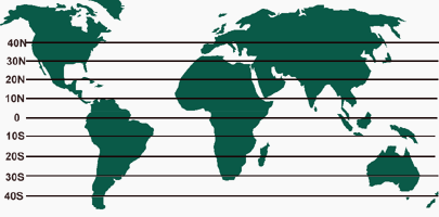
LATITUDE is a distance that can be measured on a globe.
The equator is at 0" latitude. The poles are at 90" latitude. Locations between the equator and the poles fall between 0" and 90".
Latitude measures distance north and south of the equator. It is measured in degrees. Degrees can be further broken down into minutes and seconds in order to give exact locations.
Oceans contain moving masses of water called currents which are similar to air currents. They can be warm or cold, depending on their point of origination.
Ocean currents moving away from the equator bring warm waters to a region and warm the air by conduction. Ocean currents moving away from the poles bring cold water currents to areas and cool the air by conduction.
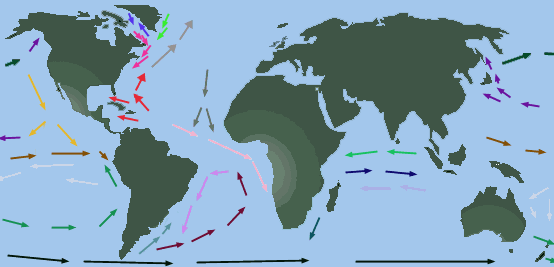
This continuous flow of warm or cool water has a direct effect on the climate of an area.
Altitude
Altitude is a measure of a location's distance above sea level. The higher above sea level, the lower the temperature. So as altitude increases, temperature decreases.
As altitude decreases, temperature increases.
Precipitation
The amount of precipitation an area will receive is affected by
PREVAILING WINDS tend to blow from one direction with a greater frequency than from other directions. These winds carry different amounts of water vapor and can bring moisture to an area or evaporate any moisture already in the area.
MOUNTAIN RANGES are barriers that can block prevailing winds. As winds attempt to rise over the mountains, it cools. This causes it to condense and form precipitation. More precipitation falls on the windward side of the mountain than on the other side.
As wind passes over a mountain peak and starts down, most of the moisture has been removed. Dry air moves down the opposite side, and little moisture is available. The leeward side of the mountain is dry and receives little moisture.
Mountains affect precipitation.
PICTURE: MOUNTAIN
CLIMATE ZONES
By looking at the earth from a distance, patterns of climate can be seen. There are cold dry areas near the poles, hot moist areas near the equator, and average conditions between the poles and the equator.
There are three main climate zones:
Climate zones extend over large areas and have similar conditions. Just as different books can contain many different chapters, different types of climates can exist within each climate zone.
Let's examine some characteristics of these climates:
Icecap, Polar, and Subarctic
The icecap, polar, and subarctic areas cover most of northern Canada and Alaska. The icecap is always cold, and the temperature seldom rises above freezing. Precipitation always falls as snow.
The polar region is always cold with a long winter and a short cold summer. Very little precipitation falls here, regardless of the season.
In the subarctic, summers are cool and short, and winters are cold and long. Most of what little precipitation that falls comes during the summer months.
The tundra is flat with little vegetation. The ground is constantly frozen beneath the surface, regardless of the season of year. Temperatures are very cold.
The taiga is a very cold subarctic area that is swampy and filled with coniferous forests.
In addition to the polar, tundra, and taiga climates, there are several other climates that have distinct characteristics:
Mediterranean
Humid Subtropical
Humid Continental
Marine or Oceanic
Steppe
Desert
Mediterranean climates
are typical of southern California and the area around the Mediterranean Sea. Winters bring heavy precipitation, and almost no precipitation falls during the summer months.Vegetation in these areas tends to be dense, short, or stunted. Brushy shrubs are more evident than are trees. Thick ground cover is common.
A marine climate is typical of the northwest coast of the United States. Temperatures are cool to warm in the summer, and only slightly cooler in the winter. This climate is characterized by moderate precipitation due to moist ocean air.
You have learned that water tends to hold its temperature more stable than does land. The close proximity of the ocean in these areas helps to explain the small change of temperature evident between the seasons.
This type of climate produces thick forests of needle-leafed trees.
Continental climates
are characterized by being moist or humid. They can be found in the northern United States. Polar air masses cause extremely cold winters with precipitation. Tropical air masses during the summer bring high temperatures and more precipitation or humidity.Vegetation can range from forests of broad or needle-leafed trees to areas of tall grass prairies. Vegetation is abundant due to the moderate precipitation available during all seasons.
Humid subtropical climates
can be found in the southeastern United States. High temperatures and precipitation characterize the long summer months. Winters are short and fairly mild, and only occasionally does the temperature drop below freezing.Broadleafed forests are prevalent in these areas due to moderate precipitation available during all seasons.
A steppe climate is similar to that found in the Great Plains of the United States and in a belt across the central section of Africa. Australia and Asia also have steppe regions.
Very little precipitation falls, and temperatures are hot in the summers and cold in the winters. Even daily temperature can experience wide variations.
This climate tends to produce grasslands or plains.
Desert climates receive very little precipitation and are usually hot and dry during the day although temperatures drop drastically at night. Deserts and steppes receive so little precipitation because of their interior location far from oceans and because mountains block the moist air.
Remember that land loses and gains heat more rapidly than water. This causes land-locked areas to have hot summers and cold winters. Vegetation is usually sparse but can include cacti, succulents, and stunted trees.
PICTURE: CACTI
Now let's examine the characteristics of these climates:
Tropical Wet Rain Forest - Highlands - Savanna
Tropical rainforests
can be found along the Amazon and Congo rivers. Here the air is constantly hot and humid. Rain falls on most days. Vegetation is thick and grows quickly. Plants tend to be broadleafed, and trees grow to enormous heights.A highland climate is difficult to characterize. It is dependent on the altitude at which it is located. The elevation and the presence or absence of prevailing winds will affect this climate.
Savannas
are grasslands that lie between deserts and rainforests. They make up more than two-fifths of the continent of Africa. Temperatures are always hot here with precipitation that varies between the seasons. This makes alternate wet and dry seasons.
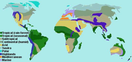
Climates of North and South America
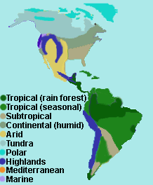
PICTURE: climate2
World Precipitation Patterns
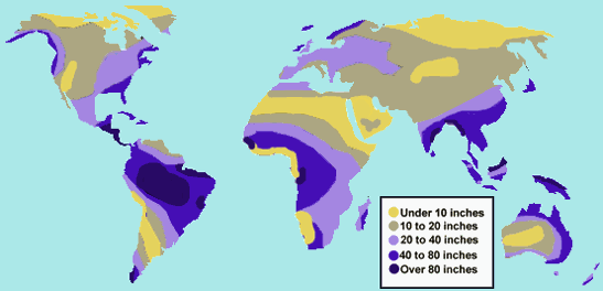
PICTURE: wprecip
Precipitation In the United States

PICTURE: usprecip
Variations in Climate
As stated earlier, weather is a day-to-day event. Climate is long term, but even climates can change with time. Climatologists believe there are three major factors that can influence the shift of a climate:
Continental Drift
Scientists propose that a supercontinent once existed which was called Pangaea. Over time, this huge supercontinent broke apart and the parts drifted. These land masses are our present continents.
If the continents of the world were cut out of a map, they could fit together in much the same way that pieces of a puzzle fit together.
PICTURE: pangaea
When Pangaea broke into sections, these sections began to drift away from one another. This shift caused worldwide climatic changes.
Sea level dropped, volcanoes became active, temperatures and precipitation levels changed. Some scientists even theorize that the extinction of the dinosaurs may have resulted from continental drift.
Plant life would have changed, directly impacting the success of the dinosaurs.
The Earth and Sun
PICTURE: erthaxis
If the direction of tilt of the earth's axis or the amount of energy the earth receives from the sun were altered slightly, drastic variations in climate could occur on earth. Many scientists directly attribute the periods known as "ICE AGES" to these two events.
Evidence exists to indicate the presence of four previous Ice Ages or major glaciations on earth. During an ice age, temperatures drop by about 6" C. Large areas that are currently inhabited become covered with a large sheet of ice. The map below shows the areas that were icebound during the last ice age.
PICTURE: iceage
Currently, the earth is experiencing an interglacial period. This is a warmer segment of time which occurs between ice ages. Sea levels are higher now than during the last ice age. Can you determine why?
The same processes which result in the earth cooling can also result in the earth warming. Just as a decrease in solar energy received can cool the earth, an increase can warm it.
Not all cooling and warming is long-term. Some events are natural and predictable.
EL NINO (el NEEN yoh) is an event that causes temporary climatic warming in a region. El Nino can be expected every two to seven years and can bring drought to one region and heavy rains with flooding to another region.
El Nino is a current of warm water that warms the air through conduction and results in the formation of global winds.
Normally the warmest water current/sea air temperatures are found in the western Pacific. During El Nino, the warmest water current/sea air temperatures are found in the eastern Pacific.
PICTURE: elnino
This map indicates some of the predicted effects of the 1997-98 El Nino. How will the area in which you live be affected?
PICTURE: wmap
Climates change over time. The climate of today is not the same as it was 1000 years ago and will continue to change with time. Climates affect lifestyles and the overall weather.
Weather is important in our day-to-day lives. Thanks to sophisticated scientific instruments, we now have a better understanding of what factors influence our weather. We can also predict future weather events with more certainty.